Warning, in this part of our roadtrip we visited a number of lighthouses. You can't go to Maine for the first time and not visit lighthouses...it just would not count as a trip to Maine!
On this day we headed from Freeport down to visit the various lighthouses around Portland. This is Portland Head Light albeit taken from a different angle than most photographs show it. But I am leading in with this one as I have a little mystery for you. Just to the top left of the keepers house you can see a smaller lighthouse out in the bay. It shows in no other photo I took and nor can I find mention of it in any of the written guide books I picked up. So here is your chance to shine your light (get it?!) - can you identify it for me please?

This is the more frequent aspect you see this lighthouse photographed from. I read that it is the most visited, photographed and painted lighthouse in New England. Now I have to add that at least another couple also claim similar billing. Oh well. On this day the weather was variable but we did at least stay dry. Why this was important was that this was a Saturday and lighthouses are a very popular location to have an outdoor wedding. We saw our first here at Portland Head.
Our next stop was for the Cape Elizabeth Light - which is actually "Two Lights". Parking, as in most places, was in high demand and trying to find a good view of either of the Cape Elizabeth lights defeated me. Instead, I am showing you some of the pretty wildflowers that we found in many areas around Portland.

Continuing on we found the Spring Point Ledge Light near to South Portland. It is at the end of a breakwater which we started along but then retreated. The lighthouse was not open to tours that day but there were a number of people fishing from the breakwater along with some interesting seacraft and other sights. It was at this stop that we watched the CAT, the high ferry from Portland ME to Yarmouth Nova Scotia come in to berth at Portland Harbor. Again, if you want to chime in and identify the building on the left side please do. Wedding # 2 was going to happen overlooking this lighthouse some time after we left. Since we did later get rain I hope the timing worked out for the wedding party.

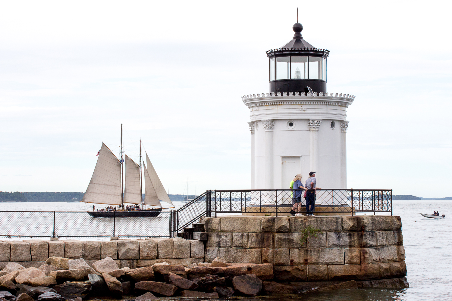
Our last lighthouse for this day was the Portland Breakwater Light ("Bug Light"). It was a constant challenge for me on this day to try and get my best shot as, being a summer Saturday, there were people everywhere. While I was waiting in vain for these folk to move away from the lighthouse another local photographer came along and commiserated with me. We both agreed that the sail boat in the background made a good shot and, oh well, you have to seize the moment. Now you might be thinking that this small lighthouse is somewhat insignificant but check out the design. The architect for this, Thomas U. Walter, was also the designer of the U.S. Capitol's east and west wings and the current dome. Wedding #3 had already happened overlooking Casco Bay.

Leaving lighthouses behind we rattled our way over the cobblestones of old town Portland and arrived at the Maine Narrow Gauge Railroad Company and Museum. Part of the experience at the Museum is the ability to take a short ride along the shore of Casco Bay in the restored rolling stock. You roll gently along for a mile and a half and then come to a halt while they disengage the locomotive and then reattach it at the other end of the train. Here the conductor is making sure that we stay within the open and closed carriages while the locomotive is moving past us.
Once #7 was back on the correct line we could get out and watch while the fireman supervised the recoupling process. Those may be weeds in the background but their bright yellow color created a good contrast to the darker colors of the railroad rolling stock and the fireman.
On this day the locomotive in use was #7 , built in 1917, from the Bridgton & Saco River Steam Railroad. This stop was specifically for the interest of the navigator who is a very keen railroad enthusiast. He later told me it was fitting we visited that day as it was the 50th anniversary of the Fifteen Guinea Special which was the last steam-hauled train on British Railways. The light drizzle of rain did not impact our visit too much.

The next morning we said our goodbyes to the Freeport area and were all set to get on the road to head north when I realized I had not documented the Big Indian located next door to where we had been staying. This towering 8' wide by 30' high fiberglass, plaster and steel rod statue has stood here on the side of route 1 in Freeport since 1969 and is a well known landmark. It was originally commissioned by the owner of the Casco Bay Trading Post and intended to draw people in to the business. Constructed in Pennsylvania the trip north of the Big Indian was a draw itself creating much slow traffic with motorists gazing in awe as they passed the big flatbed trailer. On the NJ Turnpike state troopers pulled it off the road and requested it wait until dark to continue the trip as it was causing a traffic hazard with all the rubbernecking. The Trading Post owner retired in 1989 closing the business but the Big Indian remains. Now it is a conundrum to try and figure out how to photograph it with all those unsightly wires as the backdrop.

We took a quick break from route 1 and pulled into Wiscasset. This pair was also taking a quick break.
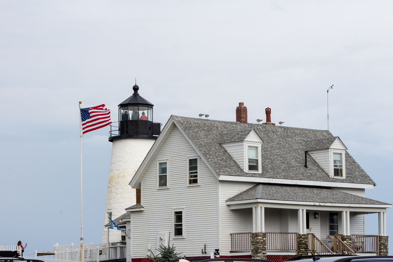
Driving on again our next stop was for the Permaquid Point Light. As we pulled into the parking lot the heavens opened and we were stuck in the car while the rain poured down for more than 30 minutes. This is another of the "most visited and famous" Maine lighthouses. Looking out across the picket fence surrounding the keepers house and into the Muscongus and John Bay you can still see the rain hanging there.

The lighthouse is not a tall one and we did take the opportunity to walk up the spiral stairway into the light area. For safety reasons this is very carefully controlled and only five people at a time can go up. While waiting our turn I noticed a cutting from a newspaper story dated December 2013 (with photo) reporting on a recent wedding here, yes, right here. The bride (in full long wedding gown) and groom, two witnesses and the officiant ascended the steep stair ladder and the wedding ceremony took place in that tiny confined space. Oh, also notice the seagulls perched on the roof. As we waited out the rainstorm we could see the gulls up there but speculated they must be fake as they stayed resolutely in position all through the downpour. But no, I guess it is just a favorite perch as the entire time we were there the seagulls came and went but there were always some perched on the rooftop of one or more of the buildings.

This photo I took from high up while in the lantern shows the rocks at low tide. It is a very real danger that the lighthouses are there to alert for.
Somewhat behind schedule because of the time lost to the rainstorm we did at last arrive at our destination, Tenants Harbor, where we would spend four nights at the East Wind Inn. A small working, fishing and boating harbor village on a peninsula near Rockland we hoped for fine weather during our time there.
To be continued.